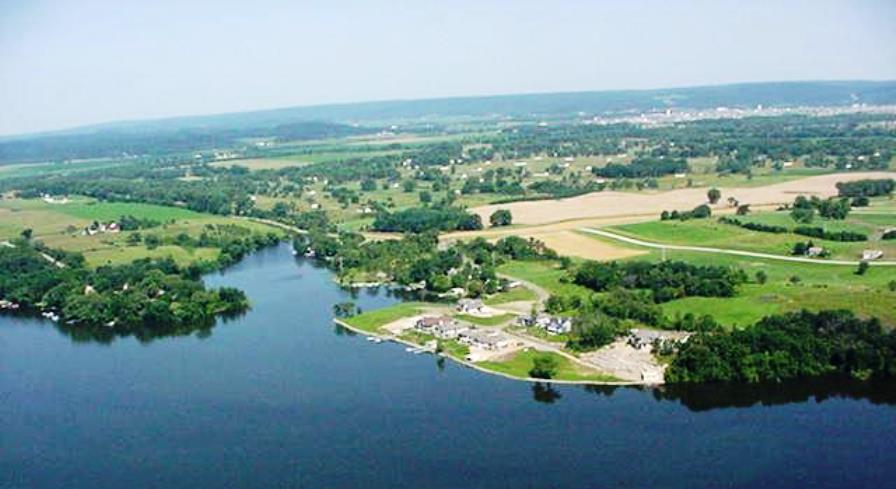
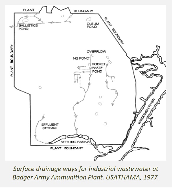
 During active production years (between 1942 and 1976), industrial wastewater was discharged from Badger Army Ammunition Plant through a series of ditches and settling ponds inside the plant and ultimately to Gruber’s Grove Bay on Lake Wisconsin – resulting in the contamination of lake bottom sediments. Sediment contaminants include lead, copper, arsenic, zinc, ammonia, nitroglycerine, nitrocellulose, PCBs and methylmercury – the most toxic form of mercury. Mercury is a highly toxic element and there is no known safe level of exposure. Ideally, neither children nor adults should have any mercury in their bodies.
Due to the presence of elevated mercury and toxic metals in bay sediments and water, Gruber’s Grove Bay was added to EPA’s Impaired Waters List (Clean Water Act Section 303d) in the year 2000. Today it remains on this priority list due to the failure of past cleanup actions.
Two previous sediment cleanups have been performed at the bay. The primary goal for cleanup was to restore the health of the aquatic environment including fisheries and the vital lake-bottom (benthic) community of the bay.
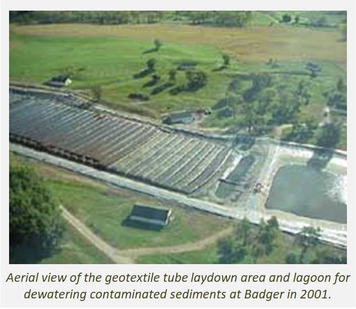
The initial bay cleanup was conducted in 2001 and resulted in the removal and dewatering of approximately 90,000 cubic yards of sediment. More than 66 million gallons of the dredged water was collected as it drained to sediment collection tubes. Water from the temporary lagoon was pumped about 0.6 mile to the northeast and spray-irrigated on 151 acres of agricultural fields and forested land.
The irrigation spray system was designed to encourage evaporation from the sprinkler heads to minimize the total amount of contaminated water that was applied to the fields. “It is assumed that a portion of the metals and ammonia nitrogen will travel with the evaporated water and will not reach the fields or forest,” the Army’s Water Management Plan stated. The irrigated water contained copper, zinc, mercury, lead, ammonia nitrogen, and sulfates – anticipated air emissions included mercury, ammonia nitrate, and ammonia gas.
Dr. Jerry Eykholt, an environmental engineer hired by the Badger Restoration Advisory Board, advised that tests could be conducted to see if disturbed or aerated sediment was releasing appreciable amounts of mercury or other contaminants to the air. Although air monitoring is commonly conducted during dredging projects, the Wisconsin DNR did not require the Army to monitor air quality.
Following the 2001 cleanup effort, sediment sampling by the Wisconsin DNR revealed that mercury was still present over a wide area at levels above the cleanup goal. The significant disparity between the WDNR sampling results and Army’s much lower results was never resolved.
With significant pressure from CSWAB and the community, the Army completed a second cleanup effort in 2006. Approximately 60,000 cubic yards of contaminated sediment were dredged over a 17-acre area. The sediment was pumped with water from the bay into 42 geomembrane tubes placed on a plastic liner on Badger land and later covered with soil. The Army reported that required sediment cleanup goals were met and sought site closure.
WDNR again performed sediment testing and found eight of the ten sediment samples exceeded the cleanup goal of 0.36 parts per million (ppm). WDNR test results for mercury ranged from 0.24 to more than 9 ppm. In August 2017, the WDNR determined that documented levels of mercury in the sediment of the bay posed an “unacceptable risk to aquatic life.”
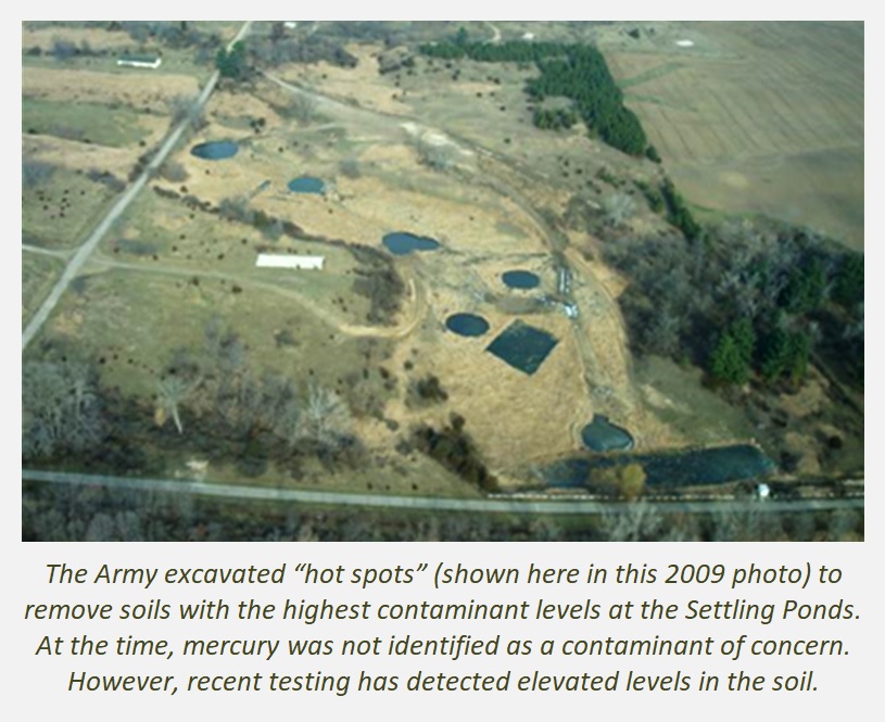
Throughout all, it is important to note that the WDNR has set an enforceable sediment cleanup goal for only mercury, believing that the other sediment contaminants were co-located. However, given the significant site disturbance these original site conditions no longer exist.
The final closure of the shared sediment burial site at Badger (for both cleanup efforts) is simply a layer of dirt. This is an unlined and unregulated unit because the WDNR granted the Army’s request for a comprehensive exemption from all state landfill regulations.
The long-term integrity of the sediment burial site (also referred to as the laydown area) is subject to a significant number of variables including the acidity of soils and the influence on mobility of metals in the environment, the degradation rate of the “filter cake” in the tubes and the tubes themselves, the transformation of mercury to methyl mercury over time and with changing inputs, the role of sulfates in the formation of methyl mercury, and erosion/disturbance of the soil cover.
In 2019, the U.S. Geological Survey (USGS) sampled sediments at Gruber’s Grove Bay to help identify the source fingerprint of mercury in the bay and to confirm the extent of contamination.
 As part of this effort, USGS tested soils in the adjacent Settling Ponds which historically carried wastewater to the bay. USGS soil sample results for total mercury ranged from 9 to 8,243 ug/kg (=ng/g or parts per billion). These levels exceed the EPA Region 4 Ecological Soil Screening Level for total mercury for multiple receptors (including plants, soil invertebrates, mammals, and birds) of 100 ug/kg. A map of the sample sites and test results is posted here.
The final site closure granted by Wisconsin DNR for the Settling Ponds area (which includes Final Creek and Spoils Disposal Areas) did not include a soil cleanup goal for mercury.
Today, sanitary wastewater from the Bluffview Sanitary District is still discharged to Final Creek (a wastewater ditch) and Settling Pond #1 where it seeps into the ground. While operated by the U.S. Army, the sanitary wastewater system influent also included landfill leachate and asbestos, according to Badger’s 2007 wastewater permit.
 HOW YOU CAN HELP!
Sign the petition for the SAFE cleanup of mercury in Gruber’s Grove Bay on Lake Wisconsin at https://cswab.org/news-action/alerts/
Reference documents:
CSWAB Update Grubers Grove Bay Mercury 11 Sept 2020 (pdf file)
Fact Sheet Cleanup and Land Use FINAL 2015
Map Grubers Grove Mercury Sediment Soil Concentrations USGS 2019
Map Industrial and Surface Water Drainage Ditches Areas Badger Army Sauk County 2007
USGS Presentation Grubers Grove Bay 12 Sept 2020
USGS Presentation Mercury Badger RAB 24 Sept 2020
WDNR Letter to Army on Dredging Grubers Grove Bay Jan 2018
PUBLIC MEETING on Gruber’s Grove Bay on Sept 24
The Army will hold its next Badger Restoration Advisory Board (RAB) meeting as a virtual meeting on September 24, 2020 at 6 p.m. The meeting is open to the public and is being conducted virtually to maintain social distancing.
If you are not a RAB member but would like to participate, please contact Kay Toye at 302-313-1770 or kaye.toye@envrg.com and she will provide information on how to join the teleconference.
The only topic on the meeting agenda is mercury. Here are the questions CSWAB has submitted in anticipation of this meeting:
CSWAB Questions for USGS relevant to Mercury:
- Please describe the test methods that USGS used to test soils and sediments for mercury at Badger. What can be learned from testing soils upgradient of the bay in areas like the Settling Ponds and Rocket Past Area that carried industrial wastewater?
- The WDNR only established a cleanup goal for total mercury based on the premise that other sediment contaminants were co-located and would be addressed by the preferred cleanup method. Since then, the bay has been dredged twice. Are mercury and other sediment contaminants still co-located?
- What steps do you recommend to establish the degree and extent of residual mercury contamination that may be present in soils at Final Creek, Settling Ponds, Spoils Disposal Area? Is this something that USGS could do?
- What is the potential impact of mercury and other bay contaminants on groundwater and nearby drinking water wells and how could this best be measured and monitored?
- What is the relationship of mercury and other contaminants in the bay to the surrounding water table?
- Can methylmercury or other sediment contaminants migrate to groundwater and nearby drinking water wells? Same question, but for the dewatering laydown areas?
- What are potential routes of exposure and associated risks to human health posed by mercury and other sediment contaminants?
- What levels of mercury are present in the water column? Is it important to know this and why?
- Is restoration of shore profiles a common step in site cleanup and recovery? What other restoration actions are common?
- Are mercury air emissions possible during sediment dredging activities? How could this be measured?
- If generated wastewater is sprayed as irrigation water, could this produce mercury and other aerosols? What would be a good way to avoid and/or monitor this potential route of exposure?
- What are the possible benefits of a silt curtain installed at on the mouth of the bay or elsewhere?
- USGS noted the potential for groundwater contaminant plumes originating in Badger to be moving under the riverway and recommended that some private wells on the other side of the river be tested. Which wells should be tested and for what analytes?
CSWAB Questions for the Army and WDNR:
- In addition to mercury will the degree and extent of ALL known and suspected contaminants of concern be documented before and after the cleanup is initiated?
- In addition to mercury, will enforceable remedial goals be established for all sediment contaminants of concern?
- What are the current levels of all other contaminants present in the bay?
- What are the current distribution patterns for all bay contaminants?
- What are the current concentrations and distribution of residual nitrocellulose (which is insoluble) in soils and sediments at the Settling Ponds, Spoils Disposal Areas, and Gruber’s Grove Bay?
- Does residual nitrocellulose at and near Badger pose a potential ignitive or reactive risk? What site data supports this?
- What are the (a) potential sources and (b) activities that could release ammonia and other air emissions during cleanup? How could these be avoided and/or monitored?
- Will the Army organize more frequent regular public meetings beginning now and throughout the bay cleanup process? Will the WDNR host its own public meeting so residents can speak directly with staff?